Pictures of England

Search:

Historic Towns & Picturesque Villages

Sandringham House

Sandringham

in the county of Norfolk

Pictures of Braithwell

in the county of South Yorkshire

About Braithwell

The borough of Rotherham is one of the administrative districts of Southern Yorkshire, it comprises of a pleasant mix of small townships, hidden hamlets and villages similar to Braithwell.

Braithwell can be found in pleasant countryside just a few miles from Rotherham and lying close to Maltby. It is an old settlement which was recorded in the Doomsday Book as Bradewelle.

The parish church dedicated to St. James is the village's oldest structure, this goes back to Norman times. The tympanum over the south doorway is carved with lattice-work, rings and stars, it is one of only a few left in the country. The addition of an aisle in the 14th century altered the shape of the building. There is a 15th century west tower and a 19th century chancel. Interesting features include the old piscina, a pulpit with panels carved with foliage and flowers, one panel features a man in a robe kneeling at prayer, another bears an inscriptions and the date 1574.

Outside, the appearance of the church sitting serenely in a wooded churchyard amongst ancient graves and tombs, is quite stunning, its strong tower is crowned with graceful pinnacles and to the rear, behind an old stone wall, there is a fresh green lawn with graves of more recent times.

The village also has an interesting War Memorial, this is built mostly of Portland stone and takes the shape of a cross with a sword. It records the dead of World War I and World War II. This is now Grade II listed and can be found on high land in a pleasant conservation area.

Braithwell lies at the centre of a largely rural community, the surrounding landscape is mostly of farms and leafy lanes siding fields full of grazing cattle and sheep. The village itself is a constant delight, it has narrow streets full of traditional stone properties, some of brick and a few of more recent times. It has a few shops, and a noted pub called the Butchers Arms. Visitors find it a friendly place to visit, with many scenic locations.

This is an ideal place to stay for anyone wishing to explore the beautiful Rother Valley, visit historic Roche Abbey or to simply soak up the atmosphere of a ribbon of ancient Yorkshire hamlets, towns and villages.

Recommended towns & villages near Braithwell

Maltby, South Yorkshire

Maltby (70 Pictures) in the county of South Yorkshire

(1.4 miles, 2.3 km, direction S of Braithwell)

The town was mentioned in the Doomsday Book, and several historic properties can be found in the region from shortly after this time, of these, of particular note are the handsome ruins of Roche Abbey, a Cistercian foundation of 1147...

A river in Doncaster

Doncaster (118 Pictures) in the county of South Yorkshire

(6.3 miles, 10.1 km, direction NE of Braithwell)

Doncaster lies in what was once a great sweep of Yorkshire coalfields. It is home to one of the finest racecourses in the country where the classic St.Leger Stakes has been run each September since 1776, making the race four years older than the Derby...

A picture of Rotherham

Rotherham (107 Pictures) in the county of South Yorkshire

(6.5 miles, 10.5 km, direction W of Braithwell)

This town was formerly a Saxon market town which remained largely unaltered until the Industrial Revolution...

Sherwood Forest near Worksop

Worksop (237 Pictures) in the county of Nottinghamshire

(9.8 miles, 15.8 km, direction S of Braithwell)

The dense spread of Worksop in Nottinghamshire meets with some seriously picturesque countryside, it is fortunate to be ringed by two rivers, the Clumber which borders Clumber Country Park, and the River Ryton...

Water falls

Sheffield (127 Pictures) in the county of South Yorkshire

(11.9 miles, 19.1 km, direction W of Braithwell)

..

All towns & villages in South Yorkshire
Complete A to Z of towns & villages in England

Nearby attractions..

Roche Abbey, Maltby

Roche Abbey (68 Pictures)

(3.0 miles, 4.8 km, direction S)

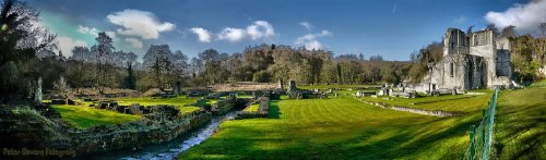
The evocative remains of Roche Abbey rising from a landscape laid out by Capability Brown present an awe-inspiring sight,.....

Conisbrough Castle, 5 miles west of Doncaster

Conisbrough Castle (16 Pictures)

(3.0 miles, 4.8 km, direction NW)

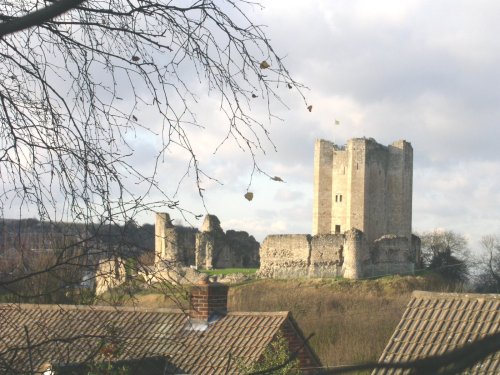
The dilapidated ruins of Conisbrough Castle make an impressive sight, particularly its keep, which is unusual in design. The.....

Thrybergh Country Park in South Yorkshire, England

Thrybergh Country Park (18 Pictures)

(3.5 miles, 5.7 km, direction W)

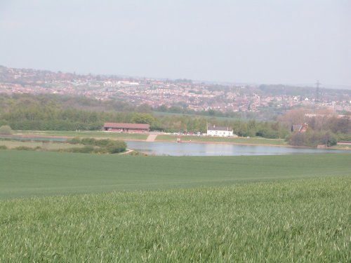
Thrybergh Country Park evolved out of Thrybergh Reservoir built in the 1800's to supply the borough of Doncaster with water. .....

A picture taken across the lake looking up at Cusworth Hall, Nr Doncaster

Cusworth Hall & Museum (40 Pictures)

(6.0 miles, 9.7 km, direction N)

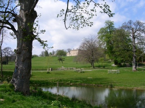
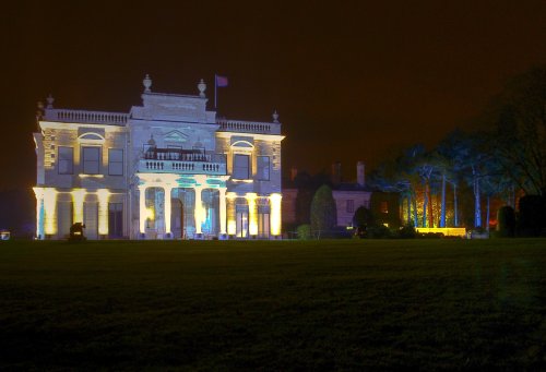
Cusworth Hall is a mid 18th century house built for the Wrightson family, with wings added later by James Paine. The house.....

A picture of Doncaster Minster

Doncaster Minster (4 Pictures)

(6.3 miles, 10.2 km, direction NE)

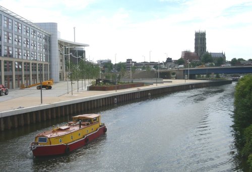
St.Georges is the Minster Church of Doncaster. It was built to a design by Sir Gilbert Scott, architect, who was instructed to.....

Brodsworth Hall at night

Brodsworth Hall (120 Pictures)

(8.1 miles, 13.1 km, direction N)

..

A picture of Sheffield Cathedral

Sheffield Cathedral (1 Pictures)

(11.8 miles, 19.0 km, direction W)

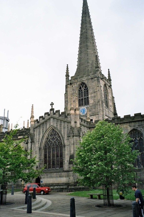
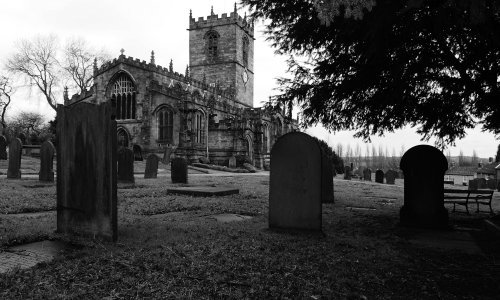
This cathedral dates mostly from the 15th century, it was the former parish church of St.Peter and St.Paul, its tower and.....


All attractions in Braithwell
All attractions in South Yorkshire
Complete A to Z of attractions in England