Pictures of England

Search:

Historic Towns & Picturesque Villages

Village sign

Burwash

in the county of East Sussex

Park Square Leeds

Leeds

in the county of West Yorkshire

Recommended Towns & Villages near Chorley

View from the footbridge at Arley near Bewdley

Bewdley (178 Pictures)

a Historic Market Town in the county of Worcestershire (7.3 miles, 11.8 km, direction SE)

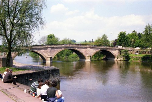
The graceful arches of the bridge designed by Thomas Telford (1757-1854) are a dominant feature of this lovely old town which nestles on the banks of the River Severn...

Wolverley Church, Wolverley, near Kidderminster (taken from the Canal)

Wolverley (16 Pictures)

in the county of Worcestershire (8.3 miles, 13.4 km, direction E)

Wolverley is a charming village at the heart of rural Worcestershire. It was mentioned in the Doomsday Book of 1086, but it is believed a settlement was there long before that...

The Bullring with All Saints Church in background. Claverley, Shropshire

Claverley (3 Pictures)

in the county of Shropshire (8.5 miles, 13.7 km, direction NE)

Claverley is surrounded by agricultural land, a short distance from delightful Bridgenorth, a picturesque town on the banks of the River Severn...

St Mary's Church

Kidderminster (42 Pictures)

in the county of Worcestershire (9.2 miles, 14.8 km, direction SE)

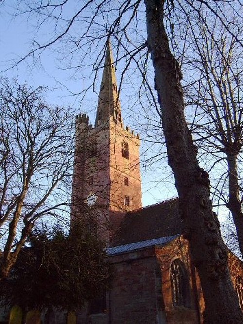
This town was once the carpet capital of England, with carpets from its mills transported to all parts of the world...

The Town  Square of Much Wenlock, Shropshire

Much Wenlock (56 Pictures)

a Historic Market Town in the county of Shropshire (11.4 miles, 18.4 km, direction NW)

..

Teme St, Tenbury Wells, Worcs.

Tenbury Wells (21 Pictures)

in the county of Worcestershire (11.5 miles, 18.6 km, direction SW)

The journey from the centre of Worcester to exquisite Tenbury Wells takes you through some of the loveliest countryside in the whole of Worcestershire...

Taken from the Norton Road

Stourbridge (14 Pictures)

in the county of West Midlands (12.6 miles, 20.2 km, direction E)

Within the vast urban sprawl that surrounds Birmingham, otherwise known as the City of a Thousand Trades, lies the once great centre for crystal glassware, Stourbridge...

Ludlow buildings

Ludlow (171 Pictures)

a Historic Market Town in the county of Shropshire (12.6 miles, 20.2 km, direction SW)

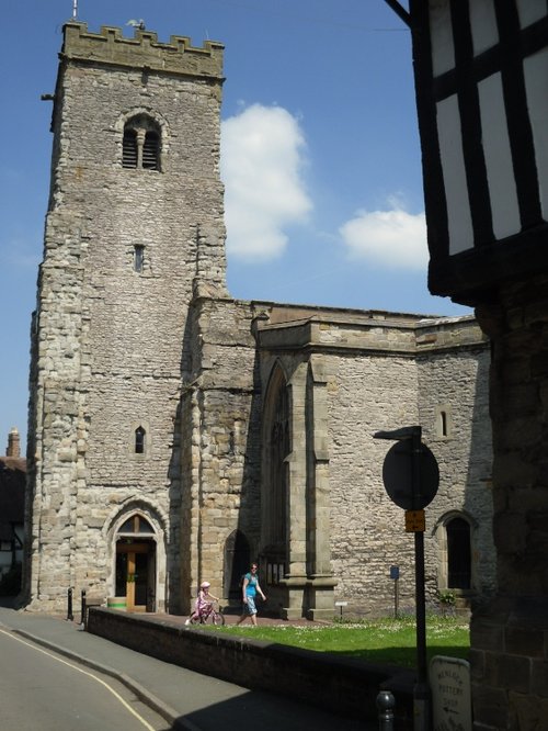
Nestling on the banks of the rivers Corve and Theme Ludlow is a joyous town to visit at any time of year...

View towards Ironbridge town

Ironbridge (169 Pictures)

in the county of Shropshire (12.6 miles, 20.3 km, direction N)

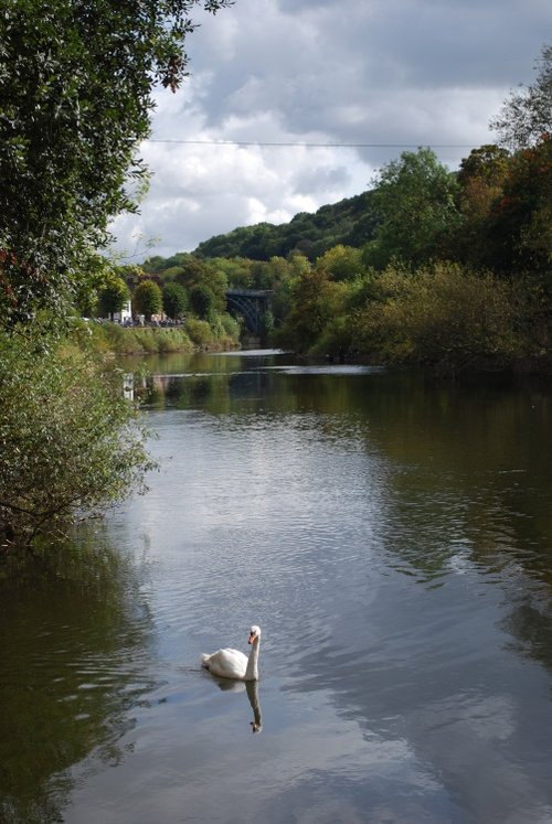
This town is named for the famous bridge that spans the River Severn - the world's first Iron Bridge....

Overton, Shropshire

Overton (1 Pictures)

in the county of Shropshire (13.9 miles, 22.4 km, direction SW)

Overton lies on a bend of the River Test a short distance from Ludlow...

Cutnall Green, Worcestershire. July morning from the field at the top of New road hill.

Cutnall Green (13 Pictures)

in the county of Worcestershire (14.5 miles, 23.3 km, direction SE)

The village of Cutnall Green lies amidst the rich agricultural landscape of Worcestershire, a short distance away from the old spa town of Droitwich...

Acton Burnell Castle, Shropshire

Acton Burnell (16 Pictures)

in the county of Shropshire (15.7 miles, 25.2 km, direction NW)

Interestingly, Acton Burnell has connections with America that go back to the stirring days of the Declaration of Independence in 1776...

Dawn

Dudley (78 Pictures)

in the county of West Midlands (16.1 miles, 25.8 km, direction E)

Dudley is a market town, it was granted its market charter in the 13th century, since then the lively outdoor market has been a focal point which has drawn regular visitors to the town...

Stokesay Castle in Shropshire

Stokesay (46 Pictures)

in the county of Shropshire (16.3 miles, 26.2 km, direction W)

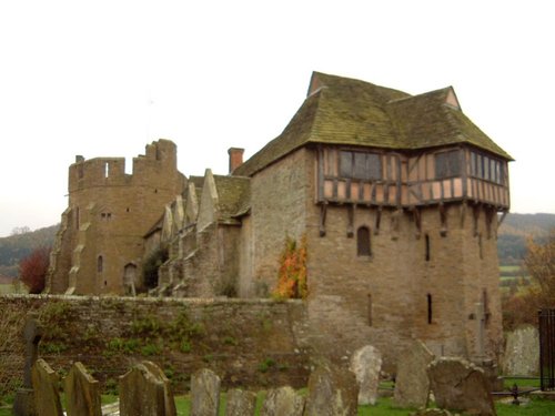
The village of Stokesay lies amid the soft rolling fields and wooded valley's of shropshire...

The Ragleth under snow, in Church Stretton, Shropshire.

Church Stretton (52 Pictures)

a Historic Market Town in the county of Shropshire (16.4 miles, 26.4 km, direction NW)

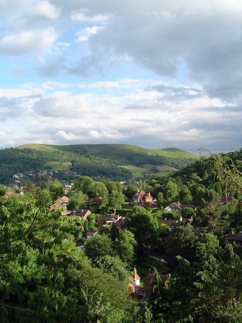
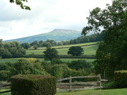
Church Stretton is an historic market town in the South Shropshire hills, and the only town in the Shropshire hills Area of Outstanding Natural Beauty - one of Britain's fiinest.....

Wolverhampton

Wolverhampton (38 Pictures)

in the county of West Midlands (16.5 miles, 26.6 km, direction NE)

..

The front of the little thatched church at Little Stretton, Shropshire

Little Stretton (4 Pictures)

in the county of Shropshire (16.5 miles, 26.6 km, direction W)

Little Stretton lies in a charming rural area a short distance from the old town of Church Stretton...

The town of Halesowen in the West Midlands

Halesowen (5 Pictures)

in the county of West Midlands (16.7 miles, 26.9 km, direction E)

For several centuries Halesowen was a farming region and despite the spread of urban sprawl the region still has nearby open beauty spots...

Lower Brockhampton Estate.

Brockhampton (5 Pictures)

a Picturesque Village in the county of Herefordshire (17.3 miles, 27.9 km, direction S)

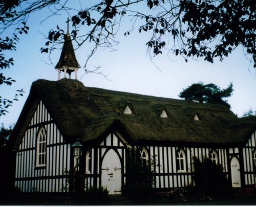
The village of Brockhampton is best known for its fine Stone and Concrete church designed by W.R.Lethaby a follower of the Arts and Crafts movement, and was built at the turn of the 20th-century. One of the beauties of the church is its stunning thatched roof, one of only three in the country...

Farmhouse and hop kilns 1986

Bromyard (16 Pictures)

a Historic Market Town in the county of Herefordshire (17.9 miles, 28.8 km, direction S)

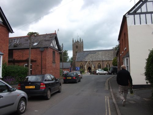
Bromyard, a pleasant market town situated equi-distance between the towns of Malvern and Leominster and, as such Bromyard is surrounded by some of the most beautiful countryside in England...

Recommended attractions near Chorley

Here kitty..here kitty...

West Midlands Safari Park (22 Pictures)

(8.4 miles, 13.5 km, direction SE)

..

Priory ruins

Wenlock Priory (28 Pictures)

(11.4 miles, 18.3 km, direction NW)

..

Benthall Hall, Shropshire

Benthall Hall (7 Pictures)

(12.3 miles, 19.8 km, direction N)

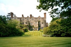
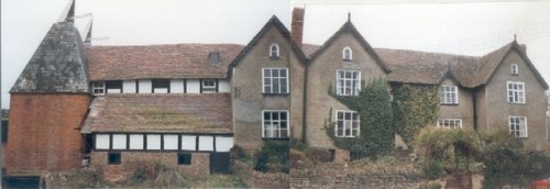
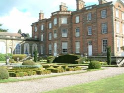
This is a beautiful stone-built house of the 16th-century which is set on a rise above the wooded slopes of the meandering River.....

The Victorian Fairground, Blists Hill, Shropshire

Blists Hill Victorian Town Museum (137 Pictures)

(12.4 miles, 19.9 km, direction N)

Blists Hill VICTORIAN TOWN is one of the largest Open Air Museums in Britain. A small Victorian town has been created above 30.....

Harvington Hall, Kidderminster, Worcestershire. Fantastic place.

Harvington Hall (12 Pictures)

(12.5 miles, 20.1 km, direction SE)

..

A step back in time!

Ludlow Castle (44 Pictures)

(12.9 miles, 20.8 km, direction SW)

Information Coming Soon..

Buildwas Abbey

Buildwas Abbey (33 Pictures)

(13.5 miles, 21.7 km, direction N)

..

The building housing the Cold War exhibition

Royal Air Force Museum (39 Pictures)

(14.8 miles, 23.8 km, direction NE)

..

Acton Burnell Castle, Shropshire

Acton Burnell Castle (4 Pictures)

(15.2 miles, 24.5 km, direction NW)

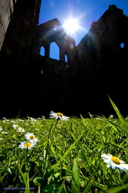
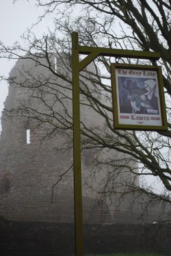
Although crenulated, the spectacular red sandstone ruins of Acton Burnell speak more of a grandiose place of comfort rather than.....

Stokesay Castle in Shropshire

Stokesay Castle (80 Pictures)

(16.2 miles, 26.1 km, direction W)

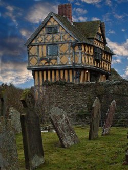
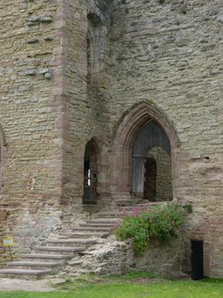
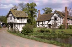
This extremely attractive building is not a castle in the traditional sense, but rather a fortified manor house and as such is.....

Ghostly tavern

Dudley Castle (17 Pictures)

(16.3 miles, 26.2 km, direction E)

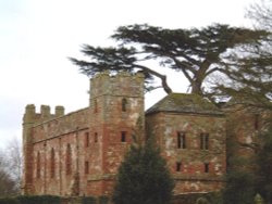
Dudley possesses one of the most important ruins in the West Midlands, the panorama from the keep of this fortress which was once.....

The Black Country Museum

The Black Country Living Museum (26 Pictures)

(16.5 miles, 26.5 km, direction E)

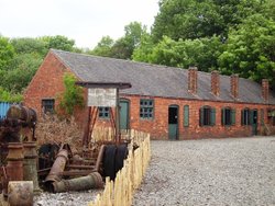
This is a delightful outdoor museum developed with flair and imagination to celebrate all that is best of the rich social and.....

Wolverhampton - St Peter`s Gardens & Art Gallery

Wolverhampton Art Gallery (8 Pictures)

(16.6 miles, 26.7 km, direction NE)

..

A picture of Mickey Miller's Family Play Barn & Maize Maze

Mickey Miller's Family Play Barn & Maize Maze (1 Pictures)

(16.8 miles, 27.1 km, direction W)

..

Looking towards Church Stretton

Carding Mill Valley & Long Mynd (11 Pictures)

(17.3 miles, 27.9 km, direction NW)

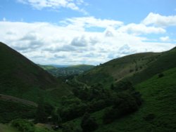
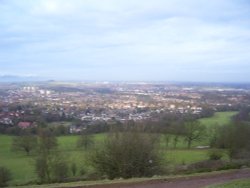
The bleak, heather clad Long Mynd lies to the west Of Church Stretton. It is a long lonely stretch covering some 10 miles in.....

Wroxeter Roman City (Viriconium) in Shropshire

Wroxeter Roman City (9 Pictures)

(17.5 miles, 28.1 km, direction NW)

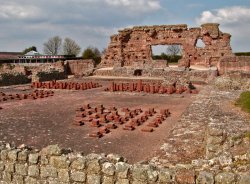
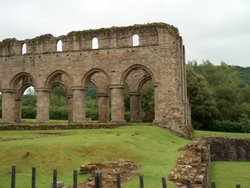
Wroxeter Roman City lies about 5 miles south-east of Shrewsbury, here lies the remains of what was the fourth largest town in.....

Lower Brockhampton Hall

Brockhampton Estate (20 Pictures)

(17.6 miles, 28.3 km, direction S)

Brockhampton Estate tells us much about the way in which our wealthy medieval ancestors lived. It comprises of a landscape of.....

Seventeenth Century Weston Park House

Weston Park (5 Pictures)

(18.1 miles, 29.1 km, direction N)

..

Looking across Rubery and Rednal from the Beacon Hill, Lickey Hills Country Park.

Lickey Hills Country Park (5 Pictures)

(18.8 miles, 30.2 km, direction E)

..

View of Long Mynd - Shropshire

The Long Mynd (18 Pictures)

(18.9 miles, 30.4 km, direction W)

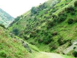
The Long Mynd (meaning "Long Mountain") is a 7 mile long heath and moorland plateau that forms part of the Shropshire hills and.....


All attractions in Chorley
All attractions in Shropshire