History of Cottingley
By Margaret Krupa
Cottingley area is mainly rural within City of Bradford Metropolitan District. It lies in the Aire Valley between Shipley and Bingley approximately 100 metres above sea level.
To the north is the A650. The land to the east of the B6269 is mainly flat and that to the west rises to a height of 170 metres at March Cote Farm.
Geologically the area consists of millstone grit with the lower slopes covered with boulder clay and some alluvial deposits. Cottingley beck cuts a deep narrow channel flowing north to the River Aire. It rises in a patch of boggy ground in Allerton Road and flows down under Sandy Lane/Haworth Road. At Sandy Lane Bridge it enters an area of deep Glacial Till. Into this the beck has dug a twenty to thirty feet deep narrow gorge crossed by a road bridge at Lee Lane. It then flows through a wooded area, with the waterfall at the rear of Lynwood Terrace, past the Cottingley Town Hall, under the road at the bottom of main Street and down to the river.
We also have the signs of a glacial drift. Crow Coal mixed with Galliard of approximately 75 ft in thickness was found in the area.
Rough rock runs down the valley to the north of Cottingley. To the south it again had coal measures. Old mine shafts litter the fields either side of Cottingley Cliffe Road. These are shown as either Old Coal Pits or Coal pits on the 1852 map of the area, which seems to suggest that some were still being worked in 1852.
Cottingley also had its own reservoir managed by Cottingley Water Works Co. This is shown above Manor Farm (now March Cote Lane) on the local map of 1908.
Cottingley was formerly on the main road before the highway was built from the Bridge to Bingley in 1825.
Stock House was the home of Mr. Thomas Baines, manufacturer.
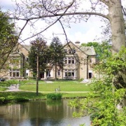
Cottingley Hall is shown on this 1908 map as situated near the site of the present Cottingley Manor Park. On the 1852 map it is referred to as Cottingley House. (As Cottingley Hall bore the date 1659 RAF (Robert & Anne Ferrand) together with the Knights double cross, it would appear that Cottingley House and Cottingley Hall are different names for the same property.)