Pictures of England

Search:

Historic Towns & Picturesque Villages

Sugar Lane, Dersingham, Norfolk

Dersingham

in the county of Norfolk

Recommended Towns & Villages near Minions

Cornish Cottage

Callington (20 Pictures)

in the county of Cornwall (6.2 miles, 9.9 km, direction E)

The little town of Callington can be found a short distance from the River Tamar and is close to the River Lynher, in a quiet region which was once known for its prosperous tin mines...

Strategic but beautiful

Launceston (20 Pictures)

a Historic Market Town in the county of Cornwall (9.6 miles, 15.5 km, direction NE)

There is a restless beauty about this stunning region, it has constantly changing vista's, the beautiful stone of enchanting houses glows in the warmth of the sun...

Watergate Bay

Watergate (10 Pictures)

in the county of Cornwall (10.9 miles, 17.5 km, direction NW)

Watergate occupies a lovely location between the picturesque fishing harbour of Padstow and the exciting surfing beaches of Newquay...

How much narrower can they get?

Looe (221 Pictures)

a Picturesque Village in the county of Cornwall (11.0 miles, 17.7 km, direction S)

In far off medieval times both East and West Looe were granted a charter and each retained its own identity for several centuries...

The Shire Hall, Bodmin, Cornwall

Bodmin (130 Pictures)

in the county of Cornwall (12.0 miles, 19.2 km, direction W)

Historically fascinating and naturally beautiful, this area of North Cornwall has so much to offer. Equidistant from both the north and south coasts, Bodmin is an excellent base.....

A street in Lostwithiel, Cornwall

Lostwithiel (27 Pictures)

in the county of Cornwall (12.3 miles, 19.8 km, direction SW)

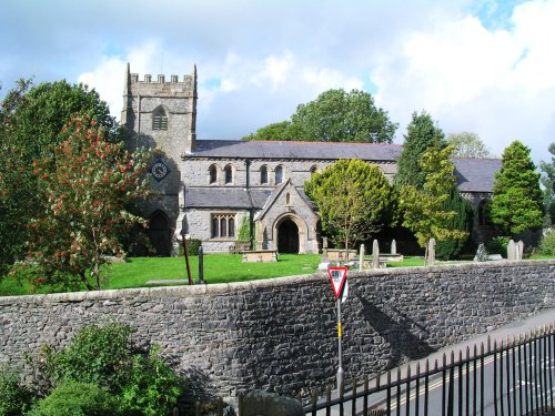
Lostwithiel, once the 13th-century capital of Cornwall and the lively centre of the tin trade, sits on the River Fowey in the heart of the Fowey Valley...

Royal Albert Rail Bridge - Saltash - June 2009 Cloudy Day

Saltash (22 Pictures)

in the county of Cornwall (12.8 miles, 20.6 km, direction SE)

Famous for its two great bridges than span the River Tamar, this little town, known as 'the gateway to Cornwall' is both pretty and interesting...

Opening to Polperro Harbour - June 2009

Polperro (213 Pictures)

a Picturesque Village in the county of Cornwall (13.1 miles, 21.1 km, direction S)

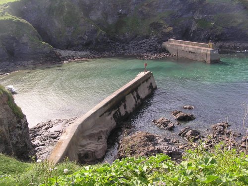
Jagged rocks rise as if to guard the entrance to the picturesque harbour of this enchanting fishing village which has for decades been a magnet for tourists and a mecca for artists from all over England...

Tavistock Parish Church

Tavistock (63 Pictures)

a Historic Market Town in the county of Devon (14.0 miles, 22.5 km, direction E)

Tavistock is located in Devon, on the edge of Dartmoor National Park. It has a rich history, a charming market, and is known for its scenic surroundings...

Looking over to Fowey taken from St. Saviours Hill, Polruan, Cornwall, June 2006.

Fowey (101 Pictures)

a Picturesque Village in the county of Cornwall (14.7 miles, 23.7 km, direction SW)

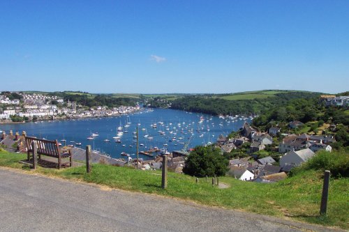
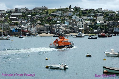
The picturesque harbour town of Fowey has a history as colourful as some of the pretty boats sailing in and out of its waters...

Poruan, Cornwall - view from Fowey

Polruan (18 Pictures)

a Picturesque Village in the county of Cornwall (15.2 miles, 24.5 km, direction SW)

A holiday resort of considerable merit and charm...

Early June evening - Polkerris harbour.

Polkerris (4 Pictures)

a Picturesque Village in the county of Cornwall (15.8 miles, 25.4 km, direction SW)

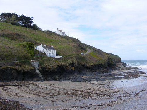
Polkerris in St.Austell's Bay has a lovely sandy beach backed by a cluster of cottages built haphazardly along a narrow village street leading towards the wooded hills and cliffs which give shelter to this enchanting little cove...

Boscastle, Cornwall

Boscastle (133 Pictures)

a Picturesque Village in the county of Cornwall (15.9 miles, 25.5 km, direction NW)

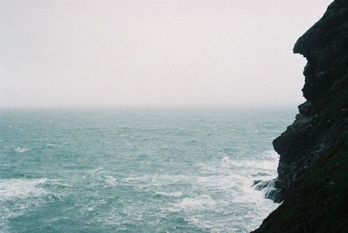
Boscastle is favoured with the only natural harbour along a rugged rock strewn twenty mile stretch of North Cornish Coast...

The Tower, Buckland Abbey, Devon

Yelverton (7 Pictures)

in the county of Devon (16.3 miles, 26.2 km, direction E)

Yelverton, by-passed by the picturesque River Meavy is situated on the south-western fringes of Dartmoor. It is a quaint little town surrounded by fine scenery with easy access to some of the loveliest places on Dartmoor...

Arthur's profile

Tintagel (197 Pictures)

in the county of Cornwall (16.6 miles, 26.7 km, direction NW)

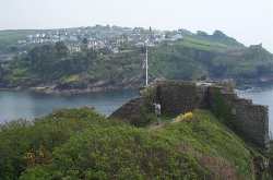
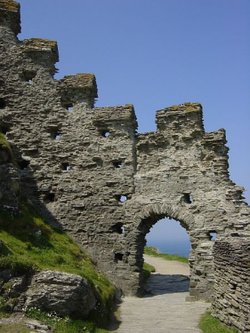
Legendry seat of King Arthur, graced with spectacular cliff scenery and the ruins of a castle built for the Earl of Cornwall in 1145, and of a Celtic Monastery. King Arthur's.....

The Main Street of Wadebridge

Wadebridge (21 Pictures)

in the county of Cornwall (17.0 miles, 27.4 km, direction W)

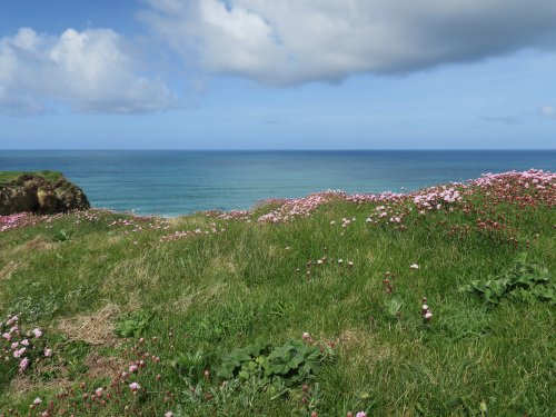
This enchanting place, is close to Padstow and Rock which are now renowed as excellent surfing resorts...

Rame Head

Rame (13 Pictures)

in the county of Cornwall (17.1 miles, 27.5 km, direction SE)

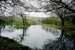
This lovely place is a nature lovers paradise. There is an abundance of wildlife including rare and beautiful birds to be occasionally seen and heard fluttering around their peaceful woodland habitat...

Port Gaverne

Port Gaverne (11 Pictures)

in the county of Cornwall (17.1 miles, 27.5 km, direction W)

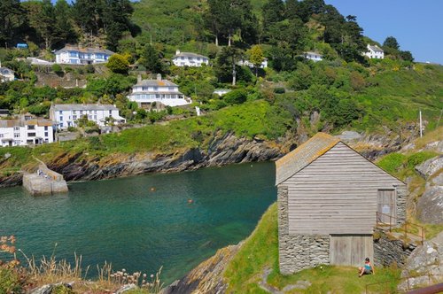
The village itself was especially noted for Pilchards, a fact which caused many fishermen in the 19th-century to make this little place their home. ..

Prysten House

Plymouth (134 Pictures)

in the county of Devon (17.2 miles, 27.7 km, direction SE)

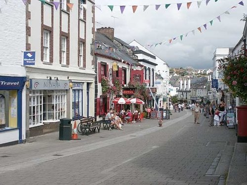
This is a city that evokes stirring memories of England's great maritime past...

Harbour walls, Port Isaac

Port Isaac (114 Pictures)

a Picturesque Village in the county of Cornwall (17.5 miles, 28.2 km, direction W)

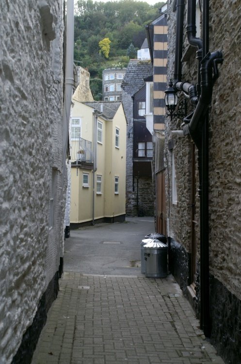
Port Isaac offers visitors many rich experiences from strolls around its ancient streets and narrow alleys criss-crossing the hillside, to simply standing on the top of a cliff watching the foaming waves of the changing tide...

Recommended attractions near Minions

Golitha Falls, near Dobwalls, Cornwall

Golitha Falls (45 Pictures)

(3.0 miles, 4.8 km, direction SW)

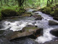
Golitha NNR (national nature reserve), known locally as Golitha Falls, is a famous beauty spot on the southern edge of Bodmin.....

The famous and historic Bodmin Moor, Bodmin, Cornwall

Bodmin Moor (69 Pictures)

(5.3 miles, 8.5 km, direction NW)

..

A young stag

Porfell Animal Land (26 Pictures)

(9.1 miles, 14.6 km, direction SW)

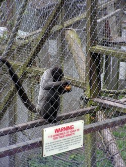
http://www.porfellanimalland.co.uk/..

Launceston Castle, Cornwall

Launceston Castle (9 Pictures)

(9.4 miles, 15.2 km, direction NE)

..

Looe Monkey Sanctuary, Cornwall. April 2005

The Monkey Sanctuary (23 Pictures)

(10.3 miles, 16.6 km, direction S)

..

No picture available

The Old Guildhall and Gaol

(11.2 miles, 18.0 km, direction S)

..

Lanhydrock springtime

Lanhydrock House (67 Pictures)

(12.0 miles, 19.3 km, direction SW)

Magnificent late Victorian country house with extensive servants' quarters, gardens and wooded estate...

The Shire Hall, Bodmin, Cornwall

The Shire Hall (2 Pictures)

(12.1 miles, 19.4 km, direction W)

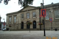
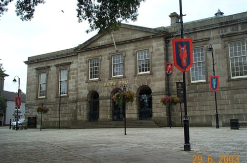
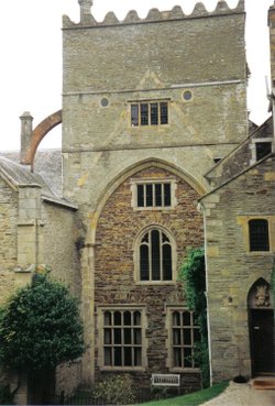
This beautifully preserved building is one of Cornwall's gems from the 19th-century. The Shire Hall was built in 1838 and shows.....

I'm going round the bend.

Bodmin & Wenford Railway (21 Pictures)

(12.1 miles, 19.4 km, direction W)

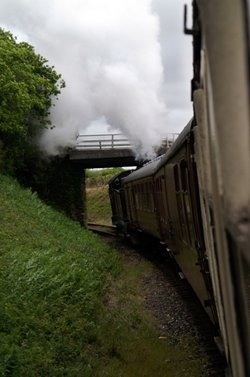
This railway is Cornwall's only standard gauge railway still operated by steam locomotives and the trains run through some.....

Restormel Castle.

Restormel Castle (45 Pictures)

(12.2 miles, 19.6 km, direction SW)

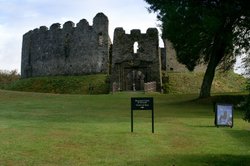
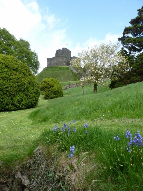
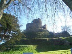
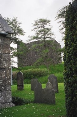
Built around 1300, once home to Edward, the Black Prince, the great circular shell-keep survives in good condition and is the.....

The Tower, Buckland Abbey, Devon

Buckland Abbey (4 Pictures)

(13.9 miles, 22.4 km, direction E)

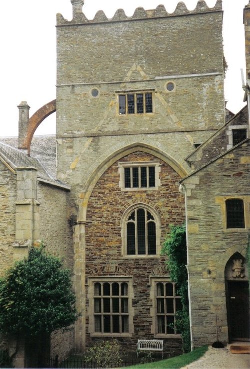
Buckland Abbey is situated near Yelverton at the edge of the Dartmoor National Park. It was built as a 13th century Cistercian.....

St. Catherine's Castle, Fowey, Cornwall

St. Catherine's Castle (18 Pictures)

(15.5 miles, 25.0 km, direction SW)

..

Tintagel Post Office, Tintagel, Cornwall

Tintagel Old Post Office (11 Pictures)

(16.6 miles, 26.7 km, direction NW)

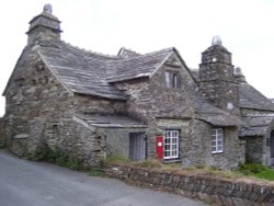
This delightful stone building with its bright red pillar-box fitted into its ancient wall is found in the coastal village of.....

Eden -  Tropical Biome

The Eden Project (182 Pictures)

(16.7 miles, 26.9 km, direction SW)

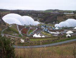
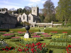
This is a joyous celebration of precious plant life established as a millennium project to mark the birth of the 21st century. .....

A picture of The Merchantant's House

The Merchantant's House (1 Pictures)

(17.2 miles, 27.7 km, direction SE)

..

Tintagel Castle - April 2004

Tintagel Castle (83 Pictures)

(17.3 miles, 27.9 km, direction NW)

The local tourist industry in Tintagel leans heavily upon tales surrounding King Arthur and the Knights of the Round Table, but.....

Inside Merlin's Cave, Tintagel, Cornwall.

Merlin's Cave (8 Pictures)

(17.4 miles, 27.9 km, direction NW)

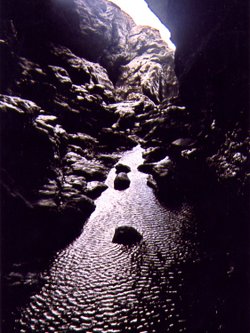
This deep cavernous black slate hole, full of eyrie atmosphere is said to be the cave where the legendry King Arthur is purported.....

Lydford Castle, Lydford, Devon

Lydford Castle (1 Pictures)

(17.4 miles, 28.0 km, direction NE)

A simple square keep is all that remains of Lydford Castle. The castle, standing on a small mound in the shadow of the church.....

Bridge over the river at Lydford Gorge, Devon.

Lydford Gorge (49 Pictures)

(17.6 miles, 28.3 km, direction NE)

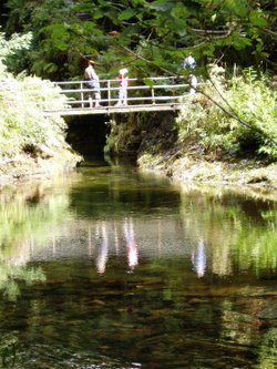
A picturesque stone bridge crosses the River Lyd just south of the village of Lydford. At this point the river often falls fast.....

Japanese Garden at Pine Lodge Gardens, St Austell, Cornwall

Pine Lodge Gardens (2 Pictures)

(17.7 miles, 28.5 km, direction SW)

..


All attractions in Minions
All attractions in Cornwall