Pictures of England
 Exploring the most Picturesque & Historic parts of England..

Pictures of Padiham

in the county of Lancashire

Padiham. Burnley Road.

About Padiham

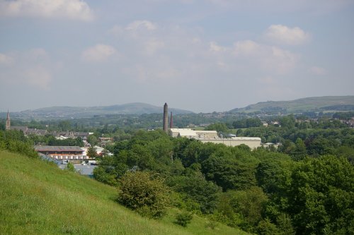
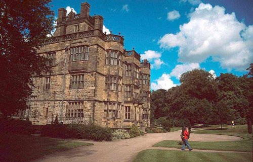
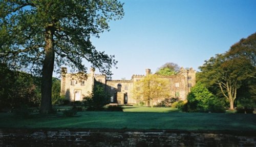
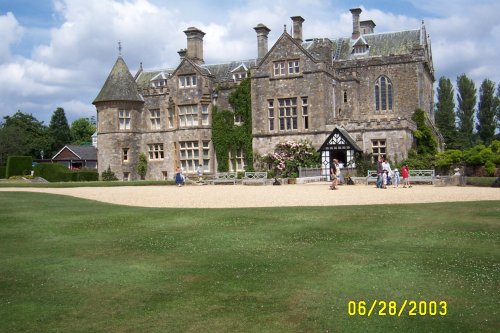
Padiham is a thriving Lancashire town lying on the Calder River. It is most famous as the home of Gawthorpe Hall, a noted country estate built early in the 17th-century for the Shuttleworth family, who owned the hall until 1970 when the house and grounds were given to the National Trust. It is now leased to Lancashire County Council.

The hall shows one of the finest textile displays in the country - the Rachel Kay-Shuttleworth collection. The Hon.Rachel (1886-1967) was a talented needle-woman who was skilled at the art of lacemaking and embroidery. During her lifetime she built up a unique collection, which as the last member of the family to live at Gawthorpe Hall, was left to the nation.

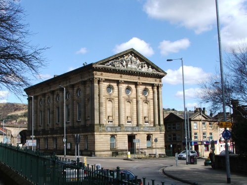
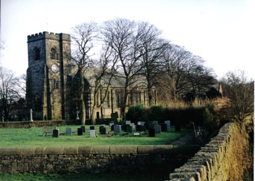
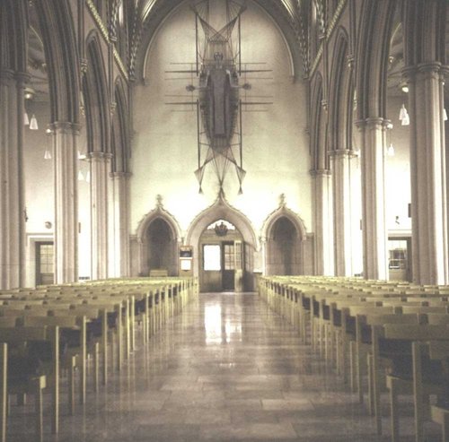
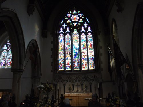
Padiham was originally a chapelry within the parish of Whalley. The Church of St.Leonard is one of the town's most impressive buildings. It was built in 1869 on the spot of a former church which was believed to have existed for several centuries. The church has a soaring clock-face tower, distinct from all areas of the town; whilst inside there are memorials to several noted families, and in the churchyard there are some magnificent tombstones from the 19th-century.

The town has curving streets where visitors can see some lovely old architecture, you only have to lift your eye's away from the tempting shop windows when a glance above will reveal three storey Georgian buildings with handsome sash windows. In an old corner of the town, curved stone steps lead up to what was quite possibly once a Victorian cottage.

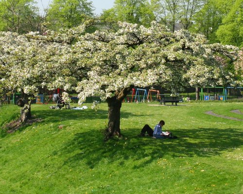
The Calder River is the towns most delightful asset, it courses its way through a myriad of trees strung out along lush river banks. At the weir, close to the former power station it is no longer unusual to see Salmon attempting to leap on their journey upstream. Along this lovely stretch of water there are several idyllic spots where good fishing can be enjoyed.

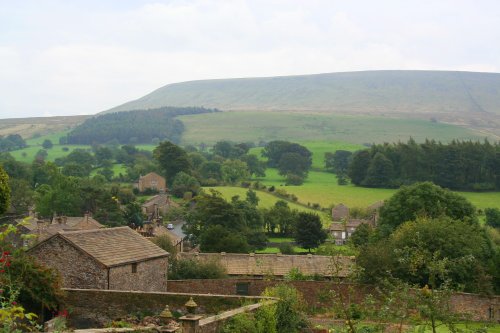
Padiham is a short distance from Burnley and within easy reach of the Bowland Forest.

Add town to favourites


Planning a visit? Please see below for other recommended towns, attractions and recommended hotels nearby.

Distances and directions below are approximate. For true driving distances please visit the AA Route Planner

Recommended attractions near Padiham

Gawthorpe Hall(0.7 miles, 1.2 km)Pictures
Forest of Burnley Country Park Millennium Site(3.6 miles, 5.8 km, direction E)Pictures
Whalley Abbey(4.3 miles, 7.0 km, direction W)Pictures
Towneley Hall Art Gallery & Museum(4.4 miles, 7.0 km, direction SE)Pictures
Pendle Hill(4.5 miles, 7.2 km, direction N)Pictures
The Ribble Valley(5.5 miles, 8.9 km, direction NW)Pictures
Clitheroe Castle(5.6 miles, 9.0 km, direction NW)Pictures
Sawley Abbey(7.8 miles, 12.6 km, direction N)Pictures
Blackburn Cathedral(8.2 miles, 13.2 km, direction SW)Pictures
Wycoller Hall(9.2 miles, 14.8 km, direction E)Pictures
Wycoller Country Park(9.5 miles, 15.2 km, direction E)Pictures
Darwen Tower(9.8 miles, 15.7 km, direction SW)Pictures
Bold Venture Park(10.1 miles, 16.2 km, direction SW)Pictures
Hothersall Hall(10.3 miles, 16.6 km, direction W)Pictures
Samlesbury Hall(11.0 miles, 17.7 km, direction W)Pictures

All attractions in Padiham
All attractions in Lancashire
Complete A to Z of attractions in England

Recommended towns near Padiham

Accrington, in the county of Lancashire (4.1 miles, 6.6 km, direction SW)
Some of the town's loveliest architecture comes from the Victorian era, this can be seen in the elegant Victorian Market Hall with its clock and rich display of sculpture.
Info | Pictures | Hotels

Barley, a Picturesque Village in the county of Lancashire (4.4 miles, 7.0 km, direction NE)
Barley is a picturesque village in Lancashire, close to Pendle hill, and is often used as a starting point for those who come to enjoy walking Pendle hill.
Info | Pictures | Hotels

Oswaldtwistle, in the county of Lancashire (5.6 miles, 9.0 km, direction SW)
This is a large, typical Lancashire village lying close to the urban sprawl of Blackburn and Accrington.
Info | Pictures | Hotels

Hurst Green, a Picturesque Village in the county of Lancashire (7.2 miles, 11.6 km, direction W)
This pretty Lancastrian villages the setting for historic Stoneyhurst, a noted school which was founded in the 16th-century.
Info | Pictures | Hotels

Waddington, in the county of Lancashire (7.4 miles, 11.9 km, direction NW)
Info | Pictures | Hotels

Ribchester, a Picturesque Village in the county of Lancashire (8.9 miles, 14.4 km, direction W)
A picturesque village in the Ribble Valley
Info | Pictures | Hotels

Ramsbottom, in the county of Greater Manchester (10.6 miles, 17.1 km, direction S)
The countryside surrounding the town offers lakes, woods and hills, with distant Winter Hill rising to a height of 456 feet.
Info | Pictures | Hotels

Todmorden, in the county of West Yorkshire (10.7 miles, 17.2 km, direction SE)
Todmorden lies on the historic border between Yorkshire and Lancashire in an area of the Calder Valley ringed by the hills of the Pennines.
Info | Pictures | Hotels

Edgworth, in the county of Lancashire (11.2 miles, 18.0 km, direction S)
This attractive hillside village occupies a pleasant rural location close to two pretty reservoirs and the historic house known as Turton Tower.
Info | Pictures | Hotels

Hoghton, in the county of Lancashire (12.2 miles, 19.6 km, direction SW)
It was here that James I created "Sirloin" when he supposedly knighted his beef!
Info | Pictures | Hotels

Slaidburn, in the county of Lancashire (12.6 miles, 20.2 km, direction NW)
An eye catching place with a pretty village green and a scattering of stone cottages set in an idyllic spot on the banks of the River Hodder.
Info | Pictures | Hotels

Dunsop Bridge, in the county of Lancashire (13.0 miles, 20.8 km, direction NW)
Info | Pictures | Hotels

Hebden Bridge, in the county of West Yorkshire (13.0 miles, 21.0 km, direction E)
This beautiful old town grew up close to the River Hebden at the point where a stone bridge was built as part of a pack-horse route in the 16th century.
Info | Pictures | Hotels

Haworth, in the county of West Yorkshire (15.1 miles, 24.3 km, direction E)
Haworth is famous the world over for its connections with the Bronte sisters, the famous novelists.
Info | Pictures | Hotels

Preston, in the county of Lancashire (16.1 miles, 25.9 km, direction W)
This is the town that was at the centre of the cotton spinning industry for well over a hundred and fifty years.
Info | Pictures | Hotels

All towns in Lancashire
Complete A to Z of towns in England

Nearby travel help

M65 Junction 8(1.3 miles, 2.1 km, direction S)
M65 Junction 9(1.4 miles, 2.2 km, direction SE)
Hapton Station(1.4 miles, 2.2 km, direction S)
Rose Grove Station(1.8 miles, 2.9 km, direction SE)
Leeds Bradford International Airport(26.9 miles, 43.3 km, direction E)
Blackpool Airport(29.5 miles, 47.5 km, direction W)
Padiham to London(183.3 miles, 295.0 km, direction SE)

Hotels & Accommodation in Padiham

Hotel NameApproximate distance from Padiham center
Higher Trapp Country House Hotel(1.4 miles, 2.3 km, direction NW)
Sparth House Hotel(3.1 miles, 5.0 km, direction SW)
The Keirby Park Hotel(3.2 miles, 5.2 km, direction E)
The Sparrow Hawk(3.2 miles, 5.2 km, direction E)
Oaks Hotel(3.3 miles, 5.4 km, direction E)
The Alexander Hotel(3.7 miles, 6.0 km, direction E)
Clarion Hotel Blackburn(4.8 miles, 7.7 km, direction W)
Holden Vale Hotel(7.5 miles, 12.1 km, direction S)
Eaves Hall Country Hotel(7.8 miles, 12.5 km, direction NW)
Moorcock Inn Hotel(9.0 miles, 14.5 km, direction NW)
All hotels in Padiham

User Login

C.S.Lewis

UK Hotel Search

*Stay in London from just £10 per night!!*

Enter destination:

(town, attraction, airport, postcode or hotel name)
Select date:
Nights:
Rooms:

Picture Tours

More