Please login or click here to join.
Forgot Password? Click Here to reset pasword
|
England is a fascinating country, with eternal unchanged landscapes full of eye catching beauty where the sun rises over lonely outposts of beautiful, almost white sandy beaches and vast tracts of stunning countryside of amazing variety. The grandeur to be found in our National Parks, defies belief and often leaves the visitor breathless with the wonder at the unspoilt nature of the landscape. The Lake District, where the poet William Wordsworth wandered, gaining inspiration for his work has lakes clustered like jewel's set amidst craggy fells and rolling, purple moors. Solitary Coniston Water is surrounded by an intriguing grey slate village. In Victorian times both lake and village inspired the artist Ruskin and children's writer Beatrix Potter. Churning waters tumble between boulders, steely tarns reflect the high mountains around them and to the western edge, rivers flow down from the fells entering the sea at the tranquil Solway Firth.
In the north west of the Country, the Solway Firth is one of England's most dramatic estuaries, its wilderness scenery contrasts sharply with the estuary of the River Severn which is flanked by soft pastoral countryside and peaceful villages. Further south the coastal mood changes, there are historic ports like Portsmouth and Plymouth reminiscent of the Pilgrim Fathers and Sir Francis Drake. The fashionable resorts of Bournemouth and Torquay have sweeping promenades, wonderful beaches and historic hotels. The spectacular County of Cornwall is dominated by dramatic scenery and still rings with Celtic legend. It has quaint harbour-side villages, enchanting sandy coves, little fishing hamlets with cobbled streets leading down to colourful boats tied to the quay. Romantic novelist Daphne du Mauriar lived in Cornwall, her home Menabilly was the setting for her famous story - Rebecca. At the tip of the Cornish Peninsula lies Land's End, where a mass of rugged cliffs tumble into the sea. The beauty of Land's End is matched only by the chalk white cliffs of Flamborough Head on England's northern shores. Here, towering above cliffs carved from storm lashed seas of centuries, stands an 86ft high lighthouse, it has defied winds and weather since 1806. Beneath the cliffs is a lunar landscape of white chalk stacks littered with boulders, teeming with sparkling pools. Further north you will find deserted, shell covered golden beaches, often scattered with rock and interspersed by impressive castles and romantic ruins clinging to craggy outcrops. Such is the richness, diversity and magic of the English coast.
In the middle of the country the Cotswolds have a timeless appeal, here you will find long vista's of meadows once flooded by the sheep of Medieval England where wool merchants built fabled churches and mellow golden Cotswold stone mansions. These same merchants decorated the ancient market towns of Stow-in-the-Wold and Chipping Campden with impressive Tudor market houses and historic butter-crosses, still seen and admired today. Just occasionally, in an off the beaten track village you might come across such oddities as stocks and a whipping post to which angry husbands took wives and children to be publicly chastised! Stratford-upon-Avon, birthplace of the Bard is found at the heart of England. It is a showcase of Tudor architecture, to which thousands of visitors flock to trace Shakespeare's life and times.
Of our major cities, York is one of the most beautiful, and the image conjured up of a Manchester dominated by cotton mills and clogs has long since gone. Liverpool continues to tower above the Mersey River and still throbs to the music made famous by the Beatles.
Birmingham, City of a thousand trades lies in an area of farmlands and factories. It is within a short distance of Iron-Bridge and Coalbrookedale, both of which were central to the Industrial Revolution. Beyond these old, once smoke filled towns lie the rolling Blue hills of Shropshire inhabited by ruined monasteries, old abbey churches and the flower-filled riverside town of Shrewsbury.
England has 5 National Parks of which the Lake District is said to be the most beautiful. Dartmoor National Park encompasses a wilderness of barren beauty where stands eyrie Hound Tor, source of the Baskerville legend, whilst the Yorkshire Dales National Park shows ribbons of drystone walls, rich green fields, sturdy farmhouses and dark, sprawling fells. The majestic Peak District National Park has massive limestone pinnacles and spires dominating its soft shale valley's where lie pretty spa towns and villages. Here you will find man made lakes, vast deep underground caverns, yet above the ground the High Peak is as wild and lonely as anywhere in England. Close-by is Chatsworth House, palatial stately home of the Dukes of Devonshire. No other country does Stately Homes like England does, there are hundreds up and down the land. The Northumberland National Park is almost at the top of the country, it affords a breathtaking home to many wild creatures including the elusive red squirrel. Within its conurbation lie ancient hillfort's, splendid villages and rivers with crystal clear waters. At its southern fringes the park is crossed by Hadrian's Wall built by the Roman Emperor in 122 AD and from which there are views over undulating English countryside.
A contrast to the Stately piles can be found in the east of England where across the landscape of the Fens and Norfolk Broads lie dainty windmills and pretty oasthouses, these are part of England's past and are usually found along quiet waterways. The Essex and the Suffolk coast are awash with yacht moorings, while inland, the River Stour runs through lowlands and a spacious wooded valley. The richness of the scenery is perfectly reflected in the great paintings of Constable, Gainsborough and Munnings which grace grand houses and hang in the art galleries of Europe. These regions have areas rich in wildlife habitation, attracting birdwatchers and other nature lovers from all corners of the earth.
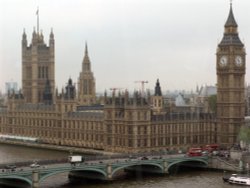
London, England's capital City, shows a proud pageant of the nations wealth. Here close to the banks of England's greatest water-way the River Thames, is a wealth of historic buildings which range from great set pieces, to grand sequences like the Mall, with the magnificent sweep of Carlton House Terrace. At the head of the Mall lies Buckingham Palace, home to Her Majesty Queen Elizabeth II. London is a vibrant, cultural cosmopolitan city with a fascinating range of theatre's, museums, art galleries, dazzling shops where you really can 'shop till you drop' and afterwards you can rest in one of London's magnificent Royal parks. London glitters at night, its pubs, clubs and cafe's rival those of any European capital.
Royal Windsor, Henley, the dreamy spires of Oxford, the enchanting ponies of the New Forest and the White Cliffs of Dover are all evocative of a fragrant rural England, which from tip to toe share scenes of infinite splendour and mystique, unrivalled by any other land.
See below for all the great towns and attractions England has to offer, or take a complete picture tour of England
| London | |
| London is one of the top cities in the world, full of history and so many beautiful and fascinating places to visit.You will never tire of all the many fascinating and exciting... | |
| Bath | |
| Bath is an elegant city famous for its beautiful Georgian architecture and its Roman attractions from which it got it's name. The traveller James Boswell who visited the city... | |
| Stow on the Wold | |
| "Stow on the Wold, where the wind blows cold" | |
| York | |
| One of the most historic cities in Britain with overs 2000 years of history... | |
| Stratford-upon-Avon | |
| Stratford Upon Avon is a beautiful historic market town in the County of Warwickshire. Famous as the birthplace of the legendry playwright William Shakespeare | |
| Clovelly | |
| Clovelly is beautiful, it retains an 'Olde Worlde' charm that even along this breathtaking coastline, is simply incomparable. | |
| Buckingham Palace | |
| Buckingham Palace is the first home and office of the Royal family in England, and has been the home to British sovereigns since... | |
| Big Ben | |
| Big Ben is famous the world over for being the giant four faced clock in London, England, but infact its not the name of the... | |
| Tower of London | |
| Historic epicentre of might and majesty, the tower has a history without parallel anywhere else in the world. With its icy past... | |
| London Eye | |
| At a height of 450 feet (135m) and 1600 tonnes, the London Eye Observation Wheel is the biggest of its kind to ever be built. It... | |
| Warwick Castle | |
| The first military encampment was built on the banks of the river Avon in Warwickshire by Ethelfleda, sister of Edward the Elder,... | |
| Alton Towers Theme Park | |
| Alton Towers is the number one theme park in England. Dating back to the Victorian times, Alton Towers closed during the outbreak... | |
| Roman Baths | |
| Bath has some of the best preserved Roman remains in Britain, with the most spectacular of these being the Roman Baths - A Roman... | |
| Blenheim Palace | |
| Home of the 11th Duke of Marlborough, Blenheim Palace has been awarded Historic Attraction of the Year 2002 and is birthplace of... | |
Follow PicturesOfEngland.com on social media and help share the beauty of England....