Ramada Crewe
Macon Way, Crewe, Cheshire, Cheshire, England
About Ramada Crewe
Ramada Crewe is a centrally located modern purposed built hotel with 64 well-appointed and stylish rooms. It is designed to meet the latest standards in 4* accomodation and boasts all the latest amenities including an express Check In/Out facility and Wi-Fi access throughout. All 64 air-conditioned bedrooms have been designed with striking interior features, providing guests with a real sense of comtemporary style and luxury.
Other nearby hotels
| Hotel Name | Approximate distance from Ramada Crewe |
| Crewe Arms Hotel | (0.3 miles, 0.5 km) |
| Royal Hotel | (0.4 miles, 0.7 km) |
| Hunters Lodge Hotel | (0.8 miles, 1.3 km) |
| Crewe Hall - A QHotel | (1.7 miles, 2.7 km, direction SE) |
| The White Lion Hotel | (2.3 miles, 3.7 km, direction SE) |
| De Vere Venues Wychwood Park | (2.6 miles, 4.2 km, direction S) |
| Rookery Hall Hotel & Spa | (3.3 miles, 5.3 km, direction W) |
| Crown Hotel | (4.3 miles, 6.8 km, direction SW) |
| Best Western Manor House Hotel | (5.5 miles, 8.9 km, direction E) |
| The Chimney House Hotel | (5.6 miles, 8.9 km, direction NE) |
| Saxon Cross Hotel | (5.6 miles, 9.1 km, direction NE) |
| Ye Olde Vicarage | (8.2 miles, 13.3 km, direction N) |
| Cranage Hall | (8.5 miles, 13.6 km, direction N) |
| Stop Inn Newcastle-Under-Lyme | (9.2 miles, 14.7 km, direction SE) |
| The Wild Boar Hotel | (9.9 miles, 15.9 km, direction W) |
| All hotels in |
Recommended attractions near Ramada Crewe
| Little Moreton Hall | (7.7 miles, 12.3 km, direction E) | Pictures |
| Mow Cop Castle | (9.1 miles, 14.7 km, direction E) | Pictures |
| Little Budworth Common Country Park | (10.0 miles, 16.1 km, direction NW) | Pictures |
| Beeston Castle | (11.0 miles, 17.6 km, direction W) | Pictures |
| Lovell Radio Telescope and Arboretum | (11.0 miles, 17.8 km, direction NE) | Pictures |
| Cholmondeley Castle | (11.2 miles, 18.0 km, direction W) | Pictures |
| Peckforton Castle | (11.4 miles, 18.3 km, direction W) | Pictures |
| Greenway Bank Country Park | (11.4 miles, 18.4 km, direction E) | Pictures |
| Biddulph Grange Garden | (11.5 miles, 18.5 km, direction E) | Pictures |
| The Potteries Museum & Art Gallery | (11.6 miles, 18.6 km, direction SE) | Pictures |
Recommended towns near Ramada Crewe
Stoke-on-Trent (11.2 miles, 18.0 km, direction NW)
Town known best as "the potteries" but in reality Stoke-on-Trent is a 1906 amalgamation of six towns, each of which still maintain their own individuality and character.
Info | Pictures | Hotels
Warrington (21.6 miles, 34.7 km, direction S)
This town can claim to have something made for Queen Victoria, which was famously rejected by her - this is the pair of Golden Gates made in 1850 for Sandringham House.
Info | Pictures | Hotels
Cheadle (20.0 miles, 32.2 km, direction W)
Cheadle has several fine black and white half timbered buildings in the town that date from the 16th-century
Info | Pictures | Hotels
Grinshill (23.1 miles, 37.2 km, direction NE)
The picturesque village of Grinshill is spread beneath Grinshill Hill, an isolated rocky outcrop which rises above the plains of the Severn Valley.
Info | Pictures | Hotels
Congleton (10.0 miles, 16.1 km, direction SW)
This lively market town stands on a bend of the River Dane, it quite possibly takes its name from the Celtic word "congle" which in English means "a bend".
Info | Pictures | Hotels
Knutsford (14.5 miles, 23.3 km, direction S)
Its name derives from Canute, the great Danish King who is said to have journeyed this way when he quite possibly forded the local stream.
Info | Pictures | Hotels
Bramhall (21.9 miles, 35.3 km, direction SW)
Set in an area where Cotton was once king, midst the towns of Manchester and the quiet rolling acres of sprawling Cheshire countryside, lies the little town of Bramhall whose most famous feature is Bramall Hall.
Info | Pictures | Hotels
Widnes (22.0 miles, 35.4 km, direction SE)
There is much that is Victorian about Widnes, this can be seen in the splendid public library building and the park named after a great Queen and Empress.
Info | Pictures | Hotels
Styal (19.2 miles, 30.9 km, direction SW)
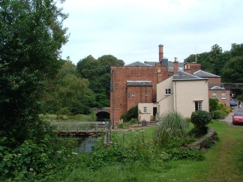
The village of Styal stands on the River Bollin close to the town of Wilmslow. It is renowned for Quarry Bank Mill and the surrounding Styal Estate with houses once occupied by the mill workers.
Info | Pictures | Hotels
Nether Alderley (15.4 miles, 24.7 km, direction SW)
Nether Alderley shows a pleasant mixture of architectural gems which include well decorated timber frame properties so typical of the glorious Cheshire landscape.
Info | Pictures | Hotels